|
|
| Home-->Travel Stories-->Copperstate 2000 Page 2 |
|
SITE CONTENTS
Please send your comments and suggestions to: Copyright
© 2008 by |
Links
on this page: Day 3 Day 4 |
|
|
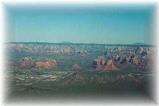
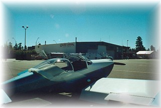
The weather in Phoenix was perfect. Temperatures in the low 80’s, clear, and no wind. Nothing much was happening at the air show because the low pressure system that brought showers to New Mexico, had the entire state of California socked in. Many of the airplanes from California that planned to attend would probably show up late Friday or Saturday. Alex and I made the decision that today, rather than Saturday, would be our “out and back” day. We packed up our cameras and light jackets and headed to the airport. We didn’t even give the shuttle service a chance at redemption as we took a cab to the airport. We threw our light gear in the back and blasted off with Sedona (SEZ), and a warm breakfast, as our destination. We climbed out of the Phoenix area and entered the valley that would take us up to Sedona and parts north. The weather was severe clear so we could see the red rocks of Sedona 50 miles out on our horizon. We also had a clear view of Mt. Humphries north of Flagstaff.
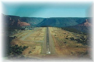
We entered the pattern and set up for a landing on runway 3. Traffic was already an issue due to Sedona’s popularity. Since traffic departs on 21 and lands on 3, care must be exercised to avoid one another. We entered downwind over Sedona and followed a red biplane that offers air tours of the surrounding countryside. We landed without a problem and parked as close to the restaurant as we could. We filled up on pancakes and omelets and discussed our next destination for the day.
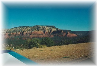
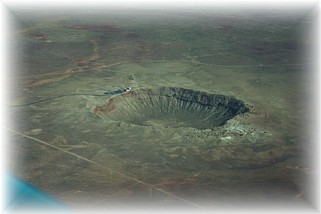
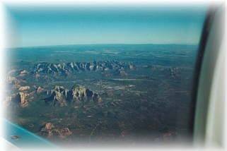
Since we were so close, I thought we’d make a quick dash to the east and make the customary circling pattern over Meteor Crater and then make a run up north to the Grand Canyon. We hopped into the airplane and fired up. It seemed that the departure from Sedona was even more spectacular than the arrival. We taxied down to the end of 21 and peered over the edge of the plateau. This is one airport were you don’t want to run off the edge of the taxiway. We made a left hand departure and circled up over the rim of the adjacent terrain on our way to Meteor Crater. In just a few minutes, you could see it on the horizon. It is just amazing how these airplanes shorten the distance between things. From this spot, we could see Payson, Meteor Crater, Sedona, Flagstaff, and on the horizon, Grand Canyon. We circled overhead and my son marveled at the force it took to create such a hole in the earth. From here we headed Northwest, directly over Flagstaff, AZ en route to Grand Canyon National (GCN) airport. We gave Mt. Humphries a wide birth as we passed by. We could see where summer forest fires had darkened her western flank. A small fire continued to burn, throwing smoke and soot up to 13,000’ where it trailed eastward in the prevailing winds.
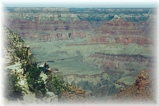
We switched over to the ATIS frequency at Grand Canyon National as we started to descend. I soon realized that this is one busy airport. We entered downwind following a twin otter and set up for landing. Grand Canyon National is at 6,600’ and it was the highest airport that we landed at. Although the temperatures were cool, I still managed to develop too high a rate of descent on final. My punishment for being inattentive was a tail wheel to main wheel porpoise down the runway three or four times. I could just hear the controllers in the tower commenting about the apparent flatlander in their midst. We were taxied down to the far end of the parking area so we wouldn’t interfere with the “more important” tourist trade. I understand why. A twin otter with living room sized picture windows down its side took off or landed about every 5 minutes. In addition, large Bell Jet Ranger helicopters were departing just as often. There was so much helicopter traffic through the airport that they had their own control tower and frequencies. This is the only airport on our trip where we were not made to feel very welcome. We shut down and clamored around various buildings looking for a ride to the south rim. Many people looked at us like we were the first ones to ever ask about a shuttle! We finally managed to acquire the telephone number of the park service shuttle and soon we were motoring up to the south rim for an afternoon of sightseeing. Seeing the Grand Canyon was the primary reason my son came on the trip and he was not disappointed. We walked the rim for an hour or so, grabbed some food, and spent a few tourist dollars in the souvenir shop. We took our time visiting because Gateway airport back in Mesa was going to be closed for the afternoon air show until 4:00 pm. We planned our departure to that we would arrive back in the valley of the sun just after that time. We departed Grand Canyon National and climbed up to avoid the afternoon desert thermals. Calm air was found at 11,500’ MSL. We cruised over Sedona again and decided to over fly Payson on our way back. Both places shined in the brilliant afternoon sunshine. I throttled back to about 1900 RPM as I had picked up a tailwind. I didn’t want to drop down into Phoenix and pound it out down low waiting for the airport to open. Even at 1900 RPM, I was still doing 135 KTS over the ground. Eventually, we swung down into Phoenix and landed via the Superstition Mall. The airport was beginning to fill up. There were definitely more airplane there now than when we left in the morning. There were about 3 ½ rows of RV’s. Upon landing, Paul Rosales stopped by to talk. Paul lives in Lancaster, CA. and I met him at the RV banquet at AirVenture. We talked about our latest adventures since Oshkosh as the fuel truck showed up. For the day we had used 24.5 gallons of fuel at $2.37/gallon for our 4.4 hours of flying fun. We cleaned off the dust and few bugs that were present, and prepped the airplane for the flight home tomorrow. Our original plan was to spend one full day at Copperstate and then leave for home on Sunday. However, there was a slow moving cold front pushing through the Midwest, with the worst of the storms still to the south. I made the decision to depart Saturday, hoping I could make it through the front before it got real nasty. After a great nights sleep, we checked out of our hotel and took a cab to the airport. Wanting to get the most out of the daylight hours, we arrived at the airport right at sun up. My son managed to climb the fence to the airport and let me in through a vehicle gate, since the field wasn’t open yet. We loaded up and departed at first light. The first leg to Moriarty, NM was as uneventful as it was beautiful. We had smooth air and a nice tail wind. We touched down for fuel in just 2.3 hours. We fueled up with 17.8 gallons at $ 2.50/gallon and departed for Liberal, KS once again. Great weather and an even stronger tail wind pushed us toward Liberal. We averaged between 185 KTS and 205 KTS ground speed and we touched down in just 2.0 hours. Another 12.4 gallons of fuel and we were ready to leave. I touched base with Flight Service. From this point on, we were going to have to deal with the weather. Radar showed two strong thunderstorm cells between Wichita and Colombia, MO. Moving north. Around these bad boys were scattered clouds and showers. There were multiple cloud layers at 7,000’ MSL and 12,000’ MSL. On the other side of the front, Columbia and St. Louis were showing broken to scattered ceilings with occasional showers. It looked a little clearer to the southeast as the thunderstorms were clearing a path behind them. Our plan would be to fly around the thunderstorms to the south and either fly under the base of the clouds, dodging the showers, or fly between the layers if things looked good on the other side. It was at this point that I made my one, big mistake of the trip. I failed to update my wife on my progress. I was so focused on navigating around the weather, that I forgot to call her. Of course, my teenage son didn’t remind me either. More on this later. We took off and hit our first clouds about ½ hour later. I didn’t relish the thought of slugging it out underneath, so I opted to climb between the layers. Fortunately, the visibility was excellent and the air was smooth. I had frequent breaks in the clouds so that I could make an emergency descent if I needed to. We angled towards the southeast and Colombia, MO. We could see the two big thunderheads and we gave them a wide berth as we swung southward. Our ground speed averaged about 185 KTS which helped to extend our range should it become necessary to utilize it. For about an hour, we flew over a solid cloud deck, but I knew that I had enough fuel to make St. Louis if necessary. Eventually, the clouds broke beneath us over Branson, MO. We circled down to find a fairly high cloud deck at 6,000’ MSL and relatively calm air. I could tell we were on the other side of the front as the OAT shot up 20 degrees as we made our descent. I had fully expected to stop in Missouri for the night but this weather encouraged me to push on. Eventually we landed in Sullivan, MO for fuel. The fall colors were just spectacular in southern Missouri. The rolling hills were alive with brilliant colors as the sun peeked over the western horizon and beneath the clouds. It was a surprising and enjoyable sight. We fueled up with 28.3 gallons at $ 2.40/gallon from our 3.2 hour leg. I remembered to telephone home this time. Boy, I had some fast explaining to do. I managed to sooth the ruffled feathers as best I could and told her we’d be home in two hours. We’d have to do this last leg at night, but Indianapolis was reporting clear skies. We made our final leg in 1.9 hours as we cruised at 3,000’ MSL just south of St. Louis, through southern Illinois, and into Indiana. The sky opened up to brilliant star shine over Illinois as we watched the harvest moon climb into the eastern night sky. What a terrific ending to our long day. The GPS put us right over Franklin Flying Field as the runways lights burst alive with the clicks of my mic button. We circled down and landed on 21 with two or three thumps. Another goal accomplished. Relief, joy, and even a tinge of sadness washed over me. I gave my son a hug as we closed the hanger doors and loaded up the truck. “Thanks Dad, he said, “That was really neat!”. Boy was it ever. |
||
|
"Destiny
is not a matter of chance, it is a matter of choice; it is not a |